 image courtesy of NASA
http://eol.jsc.nasa.gov/sseop/EFS/photoinfo.pl?PHOTO=STS034-83-69
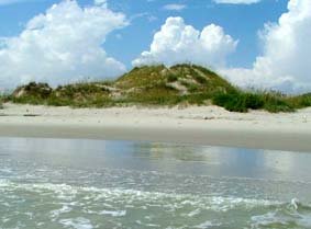
We're back from the wonderful place of sand and water called Outer Banks. Such a fragile territory, such a powerful ocean and weather. We learned about the brave men of the sea - and some of their challenges and loneliness. We learned about the value of lighthouses and climbed to the top of the tallest brick lighthouse - Hatteras.
We learned about the wind that helped give wings to the Wright brothers.
We flew kites.
But mostly we enjoyed the waves and the sand.
"STS034-83-69 Cape Hatteras, North Carolina, U.S.A. October 1989
The famous barrier island coast of Cape Hatteras, is visible in this near vertical of the North Carolina coast. This barrier island system is protected as the Cape Hatteras National Seashore, with Pamlico Sound to the west and the Atlantic Ocean to the east. A plume of sediment, visible off of the tip of Cape Hatteras, creates a light blue color in the Atlantic Ocean waters. This outflow is from the precipitation runoff of Hurricane Hugo (Sept. 1989) which was still evident during the STS-34 mission (Oct. 1989). This same delayed or extended runoff phenomenon was also very marked along the periphery of the Yucatan Peninsula following Hurricane Gilbert in 1988."
2 comments:
Kites! We love kites.
looks so blue and beautiful from so high up
Post a Comment